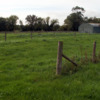
Ridge and furrow field, Honeybourne
Title
Ridge and furrow field, Honeybourne
Subject
Archaeology
Description
Photograph of ridge and furrow field on Station Road, Honeybourne, Worcestershire. Photograph taken facing roughly South-West, mid-morning. Honeybourne was recorded in the Domesday Book as Huniburn. The field has been used for the last 150 years as a sheep sale site. Wooden hurdles are stored in a barn in the field, and used to create sheep pens, with the fences along the length of the ridges, for an auction in the first week of August. This field is alongside Station Road which is part of Ryknild Street, the Roman road. (That road is also known as Rycknield Street, Icknield Street, or in Anglo-Saxon Buggild Street or Bucgan Street, and now it is called Buckle Street as it goes through the village.)
Creator
Alun Edwards
Date
8th-13th Century?
Date Created
2010-09-29
Files
Citation
Alun Edwards, “Ridge and furrow field, Honeybourne,” Woruldhord, accessed April 16, 2024, http://poppy.nsms.ox.ac.uk/woruldhord/items/show/558.

